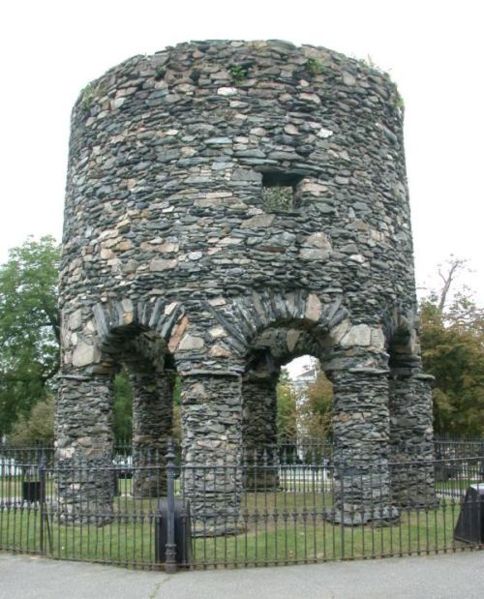
The Newport Tower
Medieval stone tower ... in Rhode Island. Does it look like any other Colonial structure you've seen? Recent carbon dating of the mortar indicates 1400s construction date (see post below).
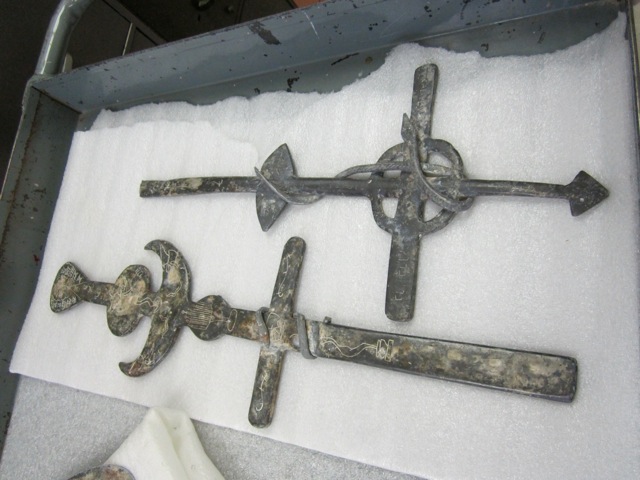
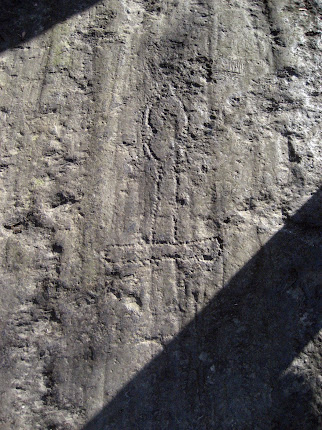
The Westford Knight Sword
Medieval Battle Sword ... in Westford, Massachusetts. Can anyone deny the pommel, hilt and blade punch-marked into the bedrock?
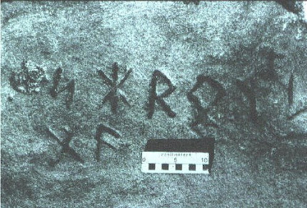
The Spirit Pond Rune Stone
Medieval Inscription ... in Maine, near Popham Beach. Long passed off as a hoax, but how many people know the Runic language? And how is it that some of the Runic characters match rare runes on inscriptions found in Minnesota and Rhode Island? Carbon-dating of floorboards at nearby long house date to 1405.
The Narragansett Rune Stone
Medieval Inscription ... in Rhode Island's Narragansett Bay. This Runic inscription is only visible for twenty minutes a day at low tide--is this also the work of a modern-day, Runic-speaking hoaxster?
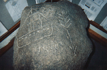
The Westford Boat Stone
Medieval Ship Carving ... in Westford, MA. Found near the Westford Knight site. Weathering patterns of carving are consistent with that of 600-year-old artifact. And why would a Colonial trail-marker depict a knorr, a 14th-century ship?
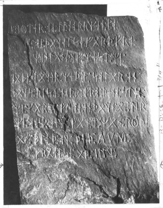
The Kensington Rune Stone
Medieval Inscription... in Minnesota. Forensic geology confirms the carvings predate European settlement of Minnesota--so did Runic-speaking Native Americans carve it?
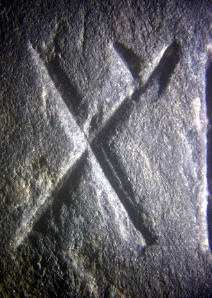
The Hooked X Rune
Medieval Runic Character ... on inscriptions found in Maine, Minnesota and Rhode Island. But this rare rune was only recently found in Europe. This conclusively disproves any hoax theory while also linking these three artifacts together.
Tuesday, February 21, 2023
Tuesday, December 7, 2021
Friday, July 23, 2021
I don’t often weigh in on the Oak Island mystery, though I do regularly watch the Curse of Oak Island show. There are plenty of capable and qualified researchers working on this mystery, and I prefer to focus on less well-known historical enigmas. However, as a Templar historian, I do sometimes uncover things relevant to the Oak Island mystery. I did so recently, something which, unless it somehow turns out to be invalid, ties the Templars to Oak Island with a high level of certainty: coconut fibers.
Coconut fibers have long been associated with the flood tunnels at Oak Island. As the theory goes, the fibers were used to prevent blockage of the box drains in the beach area of Smith’s Cove; these drains fed the flood tunnels, part of the booby-trap system used to protect the treasure buried underground in what has come famously to be known as the Money Pit. Coconuts, of course, are not native to Nova Scotia. And it is absurd to think they had floated up the coast of the Eastern Seaboard, as I have heard one archeologist suggest. Yet there they were.
I stumbled upon a research report compiled by Les MacPhie reporting on samples of the Oak Island coconut fiber having been subjected to carbon-dating by commercial laboratories. (A copy of the online report can be found here: https://www.oakislandtours.ca/.../b09_oak_island_carbon... . The second page of the report is reproduced below.) According to the report, a 1990 test by Beta Analytic yielded a date of 1180 AD, +- 60. A second test in 1996 by Woods Hole Oceanographic Institute yielded the remarkably similar date of 1185 AD, +- 35.

These dates jumped out me, being almost an exact match to the 1179 date of a purported Templar voyage to Oak Island (continuing on to the Catskill Mountains of New York) as described in the so-called Cremona Document, first extensively written about in 2017 by historian Zena Halpern. See The Templar Mission to Oak Island and Beyond, by Zena Halpern (CreateSpace 2017). See also The Scrolls of Onteora—The Cremona Document, by Donald A. Ruh (Lulu 2018). According to Halpern, the Templars deposited some or all of their treasure on Oak Island at a place labeled on a map (see below) of the island as “Le Voute en Bas de Terre,” or “The Vault Beneath the Earth” (left arrow). The map itself was labeled “Les Isle des Chene,” or “The Island of Oaks” (right arrow). (Note that this map displays a date of “1347” [not shown], perhaps indicating that it was drawn during a return visit by the Templars, subsequent to their original 1179 arrival.) This map has been regularly featured on the Curse of Oak Island show.

All of the above is available in the public record. What I was not aware of was the fact that coconuts are not native to the Americas. As of the twelfth century, coconuts were grown only in India, eastern Africa, Southeast Asia, and perhaps also Panama, but on the Pacific coast only. https://en.wikipedia.org/wiki/Coconut#Origin The Templars, it should be noted, were purported to have traveled extensively to Ethiopia (on the east coast of Africa) in the late twelfth century. See Graham Hancock, The Sign and the Seal (Touchstone 1992), at pages 103-117.
This, to me, was eye-opening. Someone brought the coconut fiber to Oak Island from one of these remote locations. Who, other than the Templars, had the wherewithal to do so in the twelfth century?
For anyone with an open mind, this evidence is difficult to shrug away.
Wednesday, July 7, 2021
My “Romerica” book focuses on dozens of Roman-era artifacts, coins and stone structures scattered around New England and the Ohio River Valley. In the book I speculate that these objects may be related to the Roman Ninth Legion, which mysteriously disappeared from the historical record after helping put down the Bar Kokhba uprising in Jerusalem in 135 AD. Since the book came out last November, I have learned of two new sites which add additional support to the possibility that Roman-era explorers came to America around the second century.
First, a site in the Shenandoah Valley in western Virginia appears to be an ancient iron smelting operation. I recently visited this site, known as the Arkfeld Farm. The owner has done meticulous work documenting his finds and has brought in outside experts to help with testing and dating the site. Here is a picture of what he believes to be part of the remains of the smelting operation:
From the
site, he had three different samples tested at the University of Washington using
Optically Stimulated Luminescence testing. He tested a brick, a mortar/cement
sample, and a piece of slag (a byproduct of iron smelting). The results are as
follows:
Brick Date: 10 AD +-160
Slag Date: 30 BC +-700
Mortar Date: 150 AD +-100
Furthermore,
the owner has documented similarities between this site and an iron smelting
site dating to the Roman era located near Hadrian’s Wall at the England-Scotland
border. In what may be a crucial piece to this puzzle, Hadrian’s Wall was built
and patrolled by the Roman Ninth Legion. (Note that there is no known evidence
of Native American iron smelting operations in North America.)
Second, an inscription along the
shoreline in York Harbor, Maine appears to date back to the Roman era. The inscription,
evidencing considerable aging, consists of two lines of Roman letters.
According to one source, the lettering reflects a version of the Roman alphabet
not used after the 4th century AD. (Images below are 1) photograph
of inscription and 2) “chalked-in” version, both from 1968.)
The script
appears to be an excerpt from Virgil’s Aeneid,
written c. 19 BC, and translates to: “There is far off at sea and facing a storm-beaten
shoreline, a reef often wholly submerged, and pounded by the towering breakers.”
Some commentators suggest the reef in question refers to nearby Boon Island,
where mooring holes 2-3 inches in diameter and 1 foot deep have been found.
Both these
sites appear to add corroboration to the assertions made in “Romerica” that
Roman-era explorers made their way across the Atlantic.
Monday, September 17, 2018
Columbus and the Templars
Saturday, November 25, 2017
Newport Tower Research Updates
Renowned anthropologist and researcher Dr. Gunnar Thompson recently passed away, but before he did he posted to his website ( http://marcopoloinseattle.com ) a number of maps of the
The conclusion that the
Of course, these maps don’t prove that the
My sincere thanks to Black Eagle for his candor and his willingness to help us solve the mystery of who built this amazing Tower.
Wednesday, March 29, 2017
Westford "Stone Sanctum"?
UPDATE 4/24/17: After bringing several Native American tribal elders to view the site, we now believe it may be a "women's circle" where women gathered monthly (they may have waded out in the shallow water to do so). If so, the site would likely predate the late 1600s, after which few Native Americans lived in Westford. The layout--a pathway leading to a circle--may represent the birth canal and womb, with the alter in the center perhaps representing the child. This would be similar to other Goddess fertility sites around the world which also use the "stick and ball" or "balloon" design to symbolize the birth canal and womb.
Wednesday, March 15, 2017
America's Stonehenge Revisited
Thursday, April 28, 2016
Update on Tucson Lead Artifacts
http://www.theepochtimes.com/n3/2017332-tucson-artifacts-suggest-europeans-made-it-to-new-world-in-8th-century-expert/
In my mind, this pretty much resolves this issue, making these artifacts some of the most important pieces of evidence of early exploration of America.
Tuesday, November 10, 2015
Masons, Druids and Washington, DC
Monday, January 26, 2015
America Unearthed, Hooked X & Westford Knight
Here are some images:
![]() |
| [orientation is off 90 degrees on this last image] |
![]() |
| Arrow showing location of Hooked X mark on rubbing of Westford Knight |
No doubt that critics will attempt to downplay the significance of this mark and/or argue it is a hoax of some kind. Regarding the possibility of hoax, I will note that the likelihood is negligible for two reasons:
1. The weathering of the Hooked X mark (see below).
2. The fact that the mark appears on a plaster cast made of the Knight many years before Scott Wolter began his research on the Kensington Rune Stone and first identified (and popularized) the Hooked X rune as an important clue to the Rune Stone's origin.
I also want to observe that, in reading some of the reviews of "America Unearthed," some skeptics seem unwilling to concede that even a single artifact analyzed on the show evidences even the possibility of pre-Columbian exploration of America. Let me state that another way: In these critics' minds, there is a 100% chance that 100% of the artifacts are fakes/hoaxes. I'm sorry, but that is not the world I live in. The world I live in is gray, where parts of history are unknown. This is not to say that every AU episode makes a compelling case, but the idea that every episode and every artifact is 100% flawed is untenable to me and, quite frankly, makes the critics look close-minded and agenda-driven.
I am happy to answer any questions, but I will not allow posts that are in my judgment uncivil.
Finally, here is an earlier post from 10/7/14 that I have copied and pasted in this post for easy reference:
***********************************
In late June I posted some images of what appear to be a Hooked X or Forked X on the Westford Knight carving. On August 31 researcher Jerry Lutgen, along with geologist Scott Wolter, came to Westford to photograph and examine the mark. I won't try to describe Jerry's work other than to say he uses digital imaging to create 3D images and models of the carvings he studies. Here is a color image of the Hooked X mark:
As Jerry explained it to me, because the rock is not a flat surface, the thing to focus on here is the comparative depth of the lines in question, not their absolute depth. What we are looking for is a consistency in the relative depth of the lines in question (this consistency shows a man-made origin rather than a naturally occurring one).
Looking at the X (you may need to zoom in), the "hook," and the 2 "word separator" dots on either side, we see that the upper left stem, the lower left stem, the upper right stem, the "hook" stem and the left dot all contain light blue "punch" marks within the green-colored surface. The lower right stem and the right dot are solid green amid the yellowish/orange-colored surface.
Looking at the color chart on the right of the image, we see that all the carved lines/dots in question are approximately one to one-and-a-half color gradations in depth--in other words, carved or punched at a relatively similar depth. Again, this points to a man-made origin.
We can next compare the Hooked X mark with the sword portion of the carving:
This sword area is a relatively flatter surface, and we see that the punch marks are mostly light green amid a yellowish surface (around the pommel) or dark green amid a light green surface (near the cross-guard). Again, we have a carved/punched depth equal to approximately one color gradation.
Scott Wolter has not reviewed all the data yet, but he and I had a long telephone conversation on September 26 and his preliminary conclusion is that it is 85-90% likely that the mark is indeed a man-made Hooked X carved at a time contemporaneous to the sword carving. As I understand it (and Scott has not reviewed this post), this conclusion is based on the following factors:
1. The orientation of the mark is perfectly consistent with the orientation of the rest of the carving.
2. The "word separator" dots are equally spaced on either side of the mark and positioned similarly to separator dots in other runic carvings.
3. The carving depth is consistent within the Hooked X itself and also consistent as between the Hooked X and the sword (see above).
4. The weathering profile within the Hooked X mark is consistent with the weathering within the sword carving.
5. It is extremely unlikely that a Hooked X mark and a pair of separator dots, all appearing in the proper orientation, would somehow naturally form on the face of the Westford Knight carving.
When I asked Scott why this only added up to 85-90% certainty, he laughed and said that his only hesitation was that finding a Hooked X on the Westford Knight carving was simply "too good to be true."
Wednesday, December 3, 2014
Narragansett Rune Stone, the Vinland Map, and Coincidence
1. In 1959 a wealthy banker by the name of Paul Mellon purchased the famous Vinland Map, purportedly for a million dollars, and donated it to Yale University. The map, if authentic, dates to the early 1400s.
2. In 2012, the Narragansett Rune Stone disappeared, taken from Narragansett Bay. The artifact was later recovered through the efforts of RI state law enforcement officials. According to the Providence Journal, the individual responsible for taking the multi-ton boulder from the bay was Timothy Mellon, the son of the above-named Paul Mellon.
Both the map and the rune stone play important roles in the debate regarding early exploration of North America. So is this just a coincidence?