The Newport Tower

The Newport Tower
Medieval stone tower ... in Rhode Island. Does it look like any other Colonial structure you've seen? Recent carbon dating of the mortar indicates 1400s construction date (see post below).

The Westford Knight Sword

The Westford Knight Sword
Medieval Battle Sword ... in Westford, Massachusetts. Can anyone deny the pommel, hilt and blade punch-marked into the bedrock?

The Spirit Pond Rune Stone

The Spirit Pond Rune Stone
Medieval Inscription ... in Maine, near Popham Beach. Long passed off as a hoax, but how many people know the Runic language? And how is it that some of the Runic characters match rare runes on inscriptions found in Minnesota and Rhode Island? Carbon-dating of floorboards at nearby long house date to 1405.

The Narragansett Rune Stone

The Narragansett Rune Stone
Medieval Inscription ... in Rhode Island's Narragansett Bay. This Runic inscription is only visible for twenty minutes a day at low tide--is this also the work of a modern-day, Runic-speaking hoaxster?

The Westford Boat Stone

The Westford Boat Stone
Medieval Ship Carving ... in Westford, MA. Found near the Westford Knight site. Weathering patterns of carving are consistent with that of 600-year-old artifact. And why would a Colonial trail-marker depict a knorr, a 14th-century ship?

The Kensington Rune Stone

The Kensington Rune Stone
Medieval Inscription... in Minnesota. Forensic geology confirms the carvings predate European settlement of Minnesota--so did Runic-speaking Native Americans carve it?

The Hooked X Rune

The Hooked X Rune
Medieval Runic Character ... on inscriptions found in Maine, Minnesota and Rhode Island. But this rare rune was only recently found in Europe. This conclusively disproves any hoax theory while also linking these three artifacts together.

Wednesday, March 29, 2017

Westford "Stone Sanctum"?

Visited an intriguing site in Westford, MA this weekend with Scott Wolter and his wife Janet. The site is comprised of a series of white rocks arranged in a specific pattern that appears to be ceremonial. The arrangement looks like a dandelion after it has turned white, with a stem (in this case 8 white rocks arranged in a row) leading to an orb (in this case a circle of white rocks). In the center of the circle is a large white boulder. The arrangement is oriented west to east, in the traditional layout of a Christian church (assuming the path to be the nave, the circle to be the apse, and boulder to be an altar). The arrangement is normally under water, but is visible now due to last summer's drought. The site has a number of features which make me think it is ceremonial: the orientation, the use of white rocks, its proximity to water, the church-like layout, and the use of 8 steps (8 being a sacred number to many groups). It is also close to where we think the Prince Henry Sinclair group would have traveled before climbing Prospect Hill to the Westford Knight site. Thanks to Wayne Wagner for calling this to my attention. He heard about this from Cori and Bill Ryan. Photo credits: Cori Ryan, GoogleEarth.

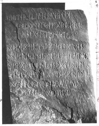
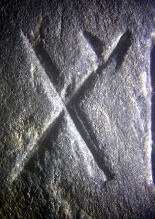
UPDATE 4/24/17: After bringing several Native American tribal elders to view the site, we now believe it may be a "women's circle" where women gathered monthly (they may have waded out in the shallow water to do so). If so, the site would likely predate the late 1600s, after which few Native Americans lived in Westford. The layout--a pathway leading to a circle--may represent the birth canal and womb, with the alter in the center perhaps representing the child. This would be similar to other Goddess fertility sites around the world which also use the "stick and ball" or "balloon" design to symbolize the birth canal and womb.


Wednesday, March 15, 2017

America's Stonehenge Revisited

I originally posted this discussion a few years ago, focusing on the fascinating summer solstice sunrise alignment connecting America's Stonehenge (North Salem, NH) to Stonehenge England and then to the Phoenician homeland of Lebanon. I now want to update: It turns out that the alignment continues, as we theorized, to the ancient Phoenician homeland at a site located in the Golan Heights in what is now Israel. The site is called Israeli Stonehenge and is also known as Gilgal Refaim, the Wheel of the Giants. Its various "spokes" and "wheels," mark the celestial and astronomical events of the year. It is, like its namesakes, essentially, a stone calendar.
 
 
The mound in the center is fifteen feet tall, and the outer circle is over 500 feet in diameter. Incredibly, the site aligns to within 1/6 of 1 degree along the summer solstice sunrise line connecting America's Stonehenge to Stonehenge England. Not bad for sites separated by 6,000 miles!
 
 
I think what happened was that the ancient seafaring Phoenicians, being sun worshipers, built these ceremonial sites as they sailed westward to trade for tin (in southern England near Stonehenge) and copper (northern New England and Great Lakes regions), both of which were needed in vast quantities during the Bronze Age. The summer solstice was the most important day of the year to sun worshipers (being the sunniest), which is why the sites are aligned on the sunrise of that day. How did they do it? The same way they navigated the oceans: through their knowledge of astronomy.
 
[Original post reprinted below]


Happy to see H2's "America Unearthed" show did such a good job with the America's Stonehenge episode that aired this weekend (and will re-air over the coming weeks). Some of the episodes have been disappointing, but this one did a good job summarizing the evidence and describing why many people feel the ancient Phoenicians build the New Hampshire site, perhaps 3500 years ago. The son of the owners of the site, Kelsey Stone, has done some fascinating work showing how the summer solstice sunrise illumination links the site to Stonehenge in England and also to the Phoenician homeland of what is modern Lebanon. Standing at the center of the NH site, and looking directly into the summer solstice sunrise, one's line of sight would pass directly through one of the arches at Stonehenge, England. Attached are images showing this phenomenom, courtesy of Kelsey Stone (on the top image, the bottom line is simply the east-west line; the upper line is the summer solstice sunrise line). The line of sight, extended, eventually would also pass through Lebanon, presumably where some ancient Phoenician temple or monument would have been erected.